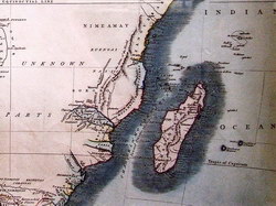
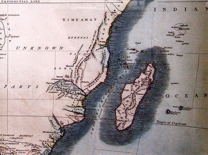
Map of Africa
Print of Madagascar detail photographed from the collection of The Royal Museum for Central Africa, Belgium
|
|
|
Unknown (1821).
|
|
Photographic Reproduction
|
Text from Information Sign
|
|
The following text is from the information notice displayed alongside the original of this map in the collection of The Royal Museum for Central Africa
CARTE DU CARTOGRAPHE ANGLAIS JOHN CARY, 1821
Cary (vers 1745-1835), un des cartographes anglais les plus représentatifs de la fin du XVIIIe et du début du XIXe siècle, édita cette carte pour la première fois en 1805. Comme tous les contemporains il s'inspira grandement du cartographe français Jean-Baptiste Bourguignon d'Anville (1697-1782) qui, avec Guillaume de L'Isle, fit progresser la cartographie de manière certaine. Ces deux cartographes firent notamment table rase de tout la géographie fantaisiste de l'Afrique intérieur et n'éprouvèrent plus le besoin de dissimuler leur manque de connaissances géographiques. Les espaces blancs font ainsi leur apparition sur les cartes (voyez les "unknown parts" chez Cary). Notons en outre que le fleuve Zaïre est encore toujours représenté à peu près comme le cours inférieur du Kwango. Le mystère du l'intérieur du continent africain demeure encore entier pendant la première moitié du XIXe siècle.
|
Text from Information Sign (English Translation)
|
MAP BY THE ENGLISH CARTOGRAPHER JOHN CARY, 1821
Cary (c.1745-1835), one of the English cartographers most representative of the late eighteenth and early nineteenth centuries, first published this map in 1805. As with all his contemporaries, he was inspired largely by the French cartographer Jean-Baptist Bourguignon d'Anville (1697-1782) who, along with Guillaume de L'Isle, was responsible for unquestionable progress in cartography. Notably, these two cartographers started with a clean slate, disregarding the fictitious geography of the African interior, and no longer felt the need to conceal their lack of geographical knowledge. White spaces thus appear on the maps (see Cary's "unknown parts"). Note further that the Zaire River is still represented roughly along the course of the lower Kwango. The mystery of the interior of the African continent remains unsolved for the first half of the nineteenth century.
|
Condition of Item
|
|
Very Good.
Refer to the glossary for definitions of terms used to describe the condition of items.
|