|
|
|
|
Front
 See both images below
Log In to Edit this page
|
Madagascar: The Plan
1942
|
(Combined Operations)
|
Edito-Service, Geneva (1977).
|
|
Trading Card
|
Text from the Back of the Card
|
Madagascar: The Plan. Countering the Japanese threat.
Preposterous though it may seem in retrospect, in January and February 1942 the Allies were genuinely fearful that the Japanese would make a serious attempt to secure Vichy-controlled Madagascar. The logistical impossibility of such an operation does not seem to have been appreciated, but there was no denying the strategic importance of the island. Madagascar dominates the southern Indian Ocean, and in unfriendly hands could seriously menace the trade route between the Gulf and the Cape. The Allies, moreover, were aware of the ambiguity of Vichy in its dealings with Japan. For all these reasons a mainly British operation to secure Diego Suarez (the only port on Madagascar of any significance) was authorised on 8th March.
The planning of the operation was complicated by the need to provide covering forces from Force 'H' in Gibraltar because none could be spared from the eastern Mediterranean and few units were available from those already in the Indian Ocean. Thus part of the Home Fleet had to be deployed to Gibraltar while the Americans moved forces into Scapa Flow. The final concentration of force for the invasion was impressive. There was a covering force of one battleship, two fleet carriers, one cruiser and seven destroyers, while the assault force, particularly strong in minor warship content, was centred on five assault ships, one LST and nine transports.
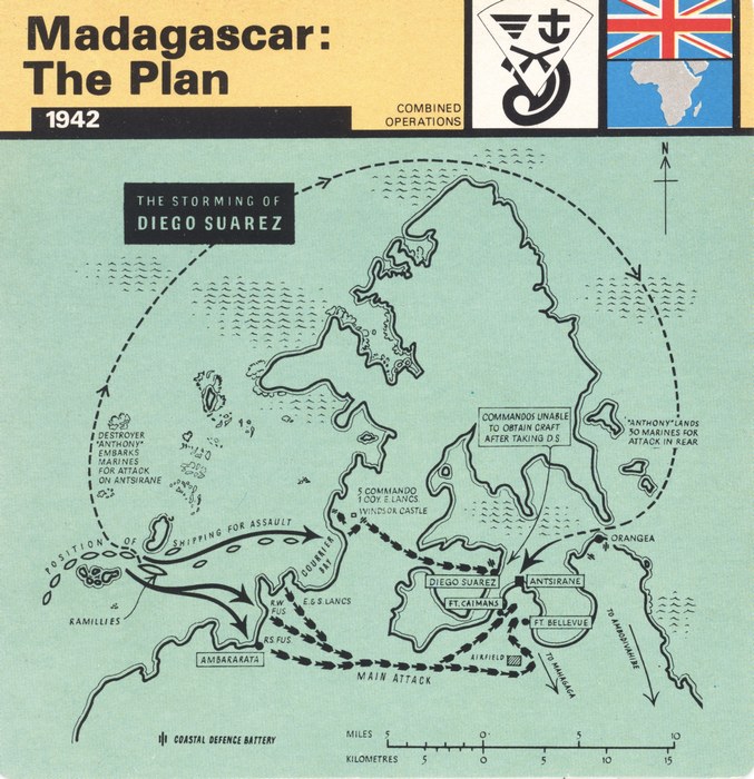
The planning of the assault was dictated by the geographical reality of Cape Amber on which stands Diego Suarez and the naval base of Antsirane. Both are washed by Diego Suarez Bay, the approaches to which through the Orangea Pass are both narrow and defended. The risks of an initial direct assault were therefore unacceptable. But Diego Suarez and Antsirane were vulnerable to an overland assault because Diego Suarez Bay cuts into Cape Amber in such a way that the ports stand on an isthmus some 10 km wide (see map). With many bays on the west coast, it was therefore desirable to assault this side of the island and move cross country onto the objectives. The shoals and reefs of the west coast were certainly preferred to the French guns on the straits.
Illustration: Map showing a plan of the assault on Diego Suarez. (Imperial War Museum, London)
|
Categories
|
|
|
|
BUY FROM AMAZON.COM
Browse 100s More Titles in our Madagascar Book Store
|
Photographs of the Item (Total: 2)
|
Click image to see larger:
 |
 |
|
|
|
| Front |
Back |
|
|
|
|
|
© 2006–2026 Daniel Austin
|